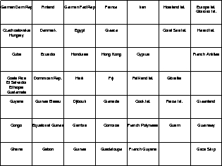
In order to simulate a distributed digital library, the documents
of the CIA Worldfactbook have been split randomly into five parts
consisting of 50 documents each.
Note that five documents are thus assigned to two parts at a time.
Each part of the library was then used for training of a separate
![]() self-organizing map.
Each of these maps represents a topologically ordered portion of its
subset of the document library.
Due to space restrictions we can only show one of these maps in this
paper, see Figure 2.
The other four maps, however, are rather similar in spirit.
self-organizing map.
Each of these maps represents a topologically ordered portion of its
subset of the document library.
Due to space restrictions we can only show one of these maps in this
paper, see Figure 2.
The other four maps, however, are rather similar in spirit.
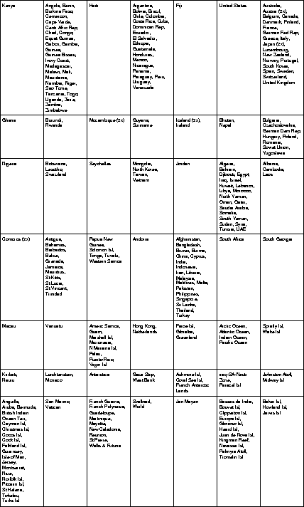
In a second step, we integrated the five independent maps
into one single
![]() self-organizing map which now represents the
complete document library.
The map that results from this integration is shown in
Figure 3.
Note that the main clusters are clearly visible from the map representation,
with the information from the low level maps being arranged according
to the organizational principles of the high level map.
As examples consider the area containing African countries in the left
upper part of the map, the area of oil producing countries,
the area of countries from Latin America, or
the area of countries usually referred to as the
first world in the right upper part.
With the latter area, please note the explicit distinction into countries
belonging to the Western hemisphere and those belonging to the
Eastern hemisphere1.
Finally, it is worth noting that the countries that are contained twice
in the library are pairwise assigned to the same unit in the
integrated map.
These countries are Austria, Comoros,
Iceland, Japan, and Mozambique.
self-organizing map which now represents the
complete document library.
The map that results from this integration is shown in
Figure 3.
Note that the main clusters are clearly visible from the map representation,
with the information from the low level maps being arranged according
to the organizational principles of the high level map.
As examples consider the area containing African countries in the left
upper part of the map, the area of oil producing countries,
the area of countries from Latin America, or
the area of countries usually referred to as the
first world in the right upper part.
With the latter area, please note the explicit distinction into countries
belonging to the Western hemisphere and those belonging to the
Eastern hemisphere1.
Finally, it is worth noting that the countries that are contained twice
in the library are pairwise assigned to the same unit in the
integrated map.
These countries are Austria, Comoros,
Iceland, Japan, and Mozambique.
In a nutshell, the higher level map forms an orderly mapping based on the information contained in several low level maps, each of which representing a portion of the library. The higher level map thus is a convenient starting point for a user trying to find her orientation in a distributed digital library.